e-Atlas Update
Project 13.1
Project Leader: Dr. Eric Lawrey - AIMS
A new mapping client has been developed that provides better integration capabilities and access to map layer information.
This has allowed integration with the TRaCK (Tropical Rivers and Coastal Knowledge) Digital Atlas.
Hundreds of layers generated from this research program are now accessible through the e-Atlas. In the future the e-Atlas will integrate with many other map sources.
A new tool (based on R scripts) has been developed to allow processing and loading of datasets with many layers.
This tool has been trialled on two datasets, but is expected to be a key tool in efficiently producing visualisations for all NERP TE Hub projects as well as assisting in the display of GIS data holdings of the Torres Strait Regional Authority (TSRA).
Recent, new or updated content:
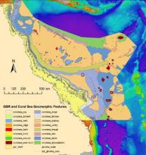
- MTSRF - Great Barrier Reef and Coral Sea Geomorphic Features (3DGBR, JCU)
- Reef Rescue Marine Monitoring Program - Inshore pesticide monitoring (Entox)
- Reef Rescue Marine Monitoring Program - Inshore water quality monitoring (AIMS)
- Reef Rescue Marine Monitoring Program - Assessment of terrestrial run-off entering the Great Barrier Reef(ACTRF-JCU)
For more information contact Eric Lawrey
Latest News
- Laws protecting the Great Barrier Reef to be introduced next week, Queensland Premier says - Thu 28th May 2015
- Let’s get serious about protecting wildlife in a warming world - Thu 28th May 2015
- We’ve only monitored a fraction of the Barrier Reef’s species - Thu 28th May 2015
- Great Barrier Reef: warmer waters helping coral-eating starfish thrive - Fri 13th Feb 2015
- You are what you eat—if you're a coral reef fish - Wed 17th Dec 2014

