Resources
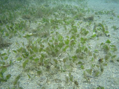 Seagrass meadows are vital habitat in tropical coastal ecosystems. However, ongoing monitoring indicates that seagrass meadows are in decline in the Great Barrier Reef where they are exposed to a range of stressors that reduce their capacity to recover after major disturbances.
Tropical Ecosystems Hub researchers used complementary laboratory and field experiments to investigate the cumulative impacts of exposure of seagrass meadows to diminished light, increased nutrients and decreased salinity, conditions that occur when water quality is reduced such as flooding and dredging.
The purpose of the research is the development of guidelines for the Great Barrier Reef Marine Park Authority (GBRMPA) for the protection of seagrass meadows, including guiding improvement to the existing Marine Monitoring Program.
The team from Project 5.3 Vulnerability of seagrass habitats in the GBR to flood plume impacts: light, nutrients and salinity tested seagrass vulnerability to water quality stressors that are typical during wet season runoff. The experiments tested environmental thresholds as well as lethal and sub-lethal indicators of stress. The tests were developed in conjunction with the GBRMPA.
This project team also mapped water quality using remote sensing, which can be used to update existing seagrass risk models. The work has provided robust and scientifically defensible environmental thresholds and has significantly enhanced the ability to detect and interpret responses to changes in water quality through high-resolution indicators testing.
The guidelines that will be developed from this project include four seagrass species and seasonally different temperatures. These will generate thresholds for species, temperature and time of light reduction. This will mean that for a specific time of exposure (e.g. duration of dredging program), the GBRMPA can state the light level required to meet that guideline. As an example, for 50% protection of seagrass density, being exposed to low light conditions for 3 months, 22.6% of surface irradiance or 7.4 mol photons m-2 d-1 is required for Z. muelleri at summer temperatures.
Large-scale water quality mapping can help define the type of seagrass communities and identify the main water types, which shape and drive seagrass response. Consequently, long term water quality data, both in-situ and through remote sensing, can provide measures of risk relative to the seagrass community health, including measures of seagrass biomass, cover and species.
This study has significantly advanced the certainty with which seagrass protection guidelines can be applied.


In April 2013 an article appeared in The Conversation labelling the hunting of dugongs as simply cruel, and Aboriginal hunting as unsustainable. A response was published in the July edition of the IUCN (International Union for Conservation of Nature) newsletter by Dr Helene Marsh, Professor of Environmental Science at James Cook University, and dugong researcher since 1973, most recently within NERP TE Hub projects 1.2 and 2.1. This article presents the response, aimed at widening the context of the debate.
Dugongs: Indigenous hunting matters, but less than some other impacts
By Helene Marsh
‘How many are there?’ and ‘How are they doing?’ are the first questions people usually ask about species of conservation concern.
These seemingly straightforward questions are tough to answer for the dugong. What we do know is that despite widespread community concerns to the contrary, dugongs are generally safer in Australia’s remote areas, where traditional hunting is the major pressure, than they are around coastal urban areas where they are impacted by habitat loss, gill netting, and vessel-strikes rather than hunting.
We don’t know how many dugongs there are globally or in Australian waters. Estimating dugong numbers is difficult because the animals mostly live in turbid water and tend to surface discreetly, often with only their nostrils breaking the surface. Our best estimates mostly come from aerial surveys combined with sophisticated statistical models. About one-fifth of the dugong’s range is in Australia.
 Dugong habitat extends from Shark Bay in Western Australia along 24,000 km of the northern coastline to Moreton Bay near Brisbane. Dugongs are the most abundant marine mammals in Australia’s northern coastal waters. While aerial survey data indicate more than 70,000 dugongs, the number is certainly higher. Large parts of the remote coasts of Western Australia and the Northern Territory have not been surveyed recently, or at all. The status of Australian dugongs varies greatly. Torres Strait is the world’s largest dugong habitat. Surveys conducted by researchers at James Cook University in Queensland show that the region contains a remarkable 58 per cent of the habitat, supporting high densities of dugongs in Queensland (see map).
Archaeological research indicates that dugongs have been hunted in Torres Strait for at least 4,000 years and that the harvest has been substantial since well before European settlement. Today, dugong hunting is permitted under the Torres Strait Treaty between Australia and Papua New Guinea (PNG) and in Australia by the Commonwealth Torres Strait Fisheries Act and the Native Title Act. The data to compare contemporary and past catch rates are not available. The current total regional dugong catch is unknown although the Torres Strait Regional Authority is attempting to correct this deficiency for Australian communities. In 2004, our modeling suggested that the current dugong catch in Torres Strait was not sustainable. This conclusion is now questioned for several reasons:
1. Dugong habitat in Torres Strait is much more extensive than previously thought. In 2010 the first seagrass survey of far western Torres Strait discovered that this very remote region supported the largest continuous seagrass bed in Australia. A subsequent extended aerial survey established that it also supports a sizable dugong population.
2. The time series of aerial surveys conducted since the mid-1980s has not demonstrated a significant decline in dugong density in Torres Strait.
3. Studies of the diving behaviour of wild dugongs fitted with timed-depth recorders and GPS-satellite transmitters indicate that the aerial survey population estimates used in the modeling are significant underestimates.
4. Studies of hunter behaviour indicate that about two-thirds of the high density dugong habitat in Torres Strait is never hunted.
This research is being used by the Torres Strait Regional Authority in negotiations with the Papua New Guinea Government and Islander leaders regarding the management of hunting. The Authority is also working with a veterinarian to address animal welfare concerns.
 In the remote Great Barrier Reef region, the dugong situation is similar to Torres Strait. However, dugongs along the urban coast have to cope with additional challenges. Analysis of the records of dugongs caught in shark nets indicated a precipitous decline in catch rates between the 1960s and 1980s. Aerial surveys since the mid-1980s indicated that the population had stabilised as a result of government management interventions. But the massive 2011 floods and cyclones reduced the dugong population to the lowest level since surveys began. Worse, the dugongs stopped breeding because of a shortage of food - no calves were seen in the region during the 2011 survey. Dugong mortalities recorded by the Queensland government’s stranding program in 2011 were the highest since comprehensive reporting began in 1998. Some dugongs migrated from the region and are now returning, but the high level of coastal development is cause for grave concern.
The most serious human impacts on dugongs along the urban coast are habitat loss, gill netting, and vessel-strikes, rather than hunting. All these impacts have associated animal welfare concerns. Concerns relating to Aboriginal hunting are accordingly misplaced. Dugong management in Australia needs to focus on much more than Indigenous hunting.
References:
(1) “In the name of culture: dugong hunting is simply cruel” Thiriet and Smith, The Conversation 7 April 2013, online at http://theconversation.com/in-the-name-of-culture-dugong-hunting-is-simply-cruel-12463
Photos:
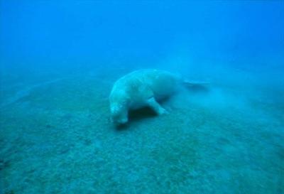
Dugong swimming. Credit: GBRMPA.
Relative density of dugongs along the coast of Queensland and adjacent Northern Territory waters based on 25 years of aerial surveys. Credit: Dr Alana Grech.
Dugong grazing. Credit: American Edu.
Dugong and diver. Credit: GBRMPA.
For further information contact: helene.marsh@jcu.edu.au
Project: 1.2 Marine wildlife management in the Great Barrier Reef World Heritage Area
Project: 2.1 Marine turtles and dugongs of the Torres Strait
 Google have recently released an amazing new product that the E-Atlas team thought you would find interesting and useful. Google have brought together all the Landsat imagery (approx. 2,000,000 scene images and 980 TB of data) and created a time animation over the last 28 years of the entire world. You can zoom and pan to any location and see the progression of change in the landscape.
The imagery is most useful for studying land changes and not the marine environment. Each yearly image uses the clearest part of the year (i.e. when there are no clouds) and as a result it does not show flood events.
Examples include:
1. Townsville’s expansion over the last 28 years. Note how dry the dam was in the mid 1980’s.
http://earthengine.google.org/#timelapse/v=-19.26674,146.77732,9.901,latLng&t=0.02
2. Moving sand dunes in off of Brisbane and possibly sand mining.
http://earthengine.google.org/#timelapse/v=-27.37774,153.41441,10.356,latLng&t=2.84
3. Expansion of agriculture around the mouth of the Burdekin River.
http://earthengine.google.org/#timelapse/v=-19.66852,147.31793,9.348,latLng&t=1.56
4. Creation of Lake Proserpine in 1991.
http://earthengine.google.org/#timelapse/v=-20.32587,148.44875,9.14,latLng&t=1.62
5. Gladstone Harbour Expansion.
http://earthengine.google.org/#timelapse/v=-23.82554,151.21819,10.052,latLng&t=2.21
6. Atherton Tablelands. Some riparian strips have improved; more forest areas have been cleared.
http://earthengine.google.org/#timelapse/v=-17.26681,145.47608,10.812,latLng&t=2.87
The e-Atlas team will be represented at the upcoming 2014 Winds of Zenadth Torres Strait cultural festival on Thursday Island from 9-12 September. This event is run every two years and brings together thousands of people from the region. The e-Atlas team will showcase the newly developed Torres Strait e-Atlas.
The Torres Strait e-Atlas is a valuable tool designed to enhance community access to information about their environments. Using a new website (http://ts.eatlas.org.au) and interactive mapping system for presenting environmental research and reference data, the e-Atlas promotes greater use and application of this information by local communities and management staff.
As Dr Eric Lawrey, the project leader for the e-Atlas, explains "The cultural festival is a great opportunity for us to engage with the broader Torres Strait community and to see what they find most useful and interesting about the e-Atlas. We have previously run a range of workshops with government stakeholders and the local Tagai State College but nothing on this scale."
At the stall, people will be encouraged to do an activity using the Torres Strait e-Atlas, in return for a specially created e-Atlas cap. There will be a large touch screen interactive display and a number of "physical" atlases to help explain some of the key concepts of the e-Atlas including base maps, map layers, and the catalogue of layers. Participants will be given a plastic slate, onto which they can choose a printed base map of the region. They will then pick from a catalogue of printed transparent map layers that they can layer together to investigate spatial relationships. Once they have made a map with the physical e-Atlas, they will then be guided through how to achieve the same result more efficiently using the online Torres Strait e-Atlas.
In addition to the cultural festival, the e-Atlas team will have one-on-one sessions with government stakeholders and will again run a classroom session at Tagai State College. The physical e-Atlas is something that should work well in a classroom setting and so it will be interesting to see how the young people and wider community interact with both the physical and online version of the Torres Strait e-Atlas.

Prototype of the physical e-Atlas with a number of layers for Torres Strait.
This teaching aid covers key e-Atlas concepts such as basemaps and map layering.
For more information, contact Dr Eric Lawrey from AIMS at e.lawrey@aims.gov.au.
 The Bright Earth e-Atlas Basemap is an improved basemap that focuses on Queensland, highlighting the natural environment and the areas of human influence rather than the traditional roadmap available from Google Maps. With this basemap we wanted to show off the Great Barrier Reef, its river catchments, the wet tropics rainforests and the Torres Strait.
The e-Atlas developed a popular basemap several years ago, however its low resolution made it unsuitable for use with many of the new high resolution datasets now available on the e-Atlas and elsewhere. The eReefs Water Quality Dashboard team are using this old basemap and requested a new higher resolution version be created. This new basemap will also become the starting point for an even higher resolution version for the Torres Strait, it will be one of the key features of the Torres Strait e-Atlas.
The new Bright Earth basemap is most detailed along the Queensland coastline at scale of 1:250k nestled seamlessly within a global map at a scale of 1:2M. This allows the e-Atlas users to zoom in and out without ever noticing the boundary of the high resolution map.
The new Bright Earth basemap was compiled mainly from open access datasets which will allow the basemap and its components to be made freely available to others. The following datasets were used: Natural Earth Data, Blue Marble Next Generation (NASA), VMap0, gbr100 (JCU), GBR Features (GBRMPA), QLUMP Landuse (DSITIA), OpenStreetMap (CloudMap), Coast100k (GA), Gulf of Papua Bathymetry (GA), STRM30 Plus (UCSD).
The new basemap will be available on the e-Atlas website, http://maps.e-atlas.org.au, from the 22nd Aug 2013.
For further information contact: e.lawrey@aims.gov.au
Project: 13.1 e-Atlas
Spear fishers have known it all along: water on inshore reefs can be pretty murky - especially early in the year, and especially after big floods. But the time scales and processes leading to changes in water clarity have not been scientifically documented to date.
Maintaining water clarity is very important for the health of the Great Barrier Reef. Corals, seagrasses and algae all depend on light, which diminishes if the water gets cloudy. High water clarity is a prerequisite for low seaweed cover, high inshore coral diversity, and high numbers of young corals to settle and replenish coral populations. Water clarity is therefore an important measure that is being used in the GBRMPA Water Quality Guidelines.
NERP researchers from the Australian Institute of Marine Science investigated how GBR water clarity is affected by river runoff. Tropical Ecosystems Hub Project 4.1 is a study based on two independent types of data.
The first study was a collaboration with the Reef Rescue co-funded AIMS Marine Monitoring Program, who maintain turbidity loggers on inshore reefs up and down the whole GBR. The researchers found that water clarity was up to 10-fold higher on inshore reefs away compared to those close to river mouths. They also showed that inshore water clarity was significantly affected by river flow and rainfall, once resuspension by waves and tides were accounted for. On the more river-exposed reefs, water clarity was high towards the end of the dry season but was reduced by over 40% on average at the end of the wet season.

The second study is a collaboration with UQ and JCU, using a 10-year time series (2002-2012) of daily satellite data of water clarity in the Burdekin Region. The researchers found a very strong relationship between annual Burdekin River loads of particulate phosphorus, and mean annual water clarity in the central GBR, an area of about 25,000 km2. Water clarity of the inshore, lagoon and midshelf, i.e. about 12 to 80 km from the coast, rapidly declined with the onset of the river floods (data were again standardised for waves and tides). For the coastal zone that is chronically turbid this relationship was weaker, because sediment on the seafloor is readily available for resuspension all year round. River floods did not affect water clarity in the offshore zone. Throughout the study region, mean annual water clarity was 20% lower in wet compared to dry years. After floods started, water clarity remained reduced by over 30% for about six to eight months, until gradually returning to clearer baseline values.
So, both studies showed that river loads affected GBR water clarity for significant periods of time every year, and especially after big wet seasons. Importantly however, the studies also showed the capacity for GBR water clarity to recover to clear levels within six to eight months after river floods. The research therefore documented that reductions in river loads of nutrients and sediments should measurably improve the GBR water clarity, in particular in inshore, lagoon and midshelf areas. This would provide significant ecosystem benefits, such as increasing coral diversity and less seaweed - and better spear fishing conditions!
Dr. Katharina Fabricius, AIMS
For more information, contact Katharina Fabricius at: k.fabricius@aims.gov.au
Conservation planning is an important pathway from environmental data to achievable conservation outcomes. But what happens when limited published data or grey literature data exists? This is the challenge facing the team from Project 9.3 ‘Prioritizing Management Actions on Great Barrier Reef Islands’.
To address this challenge, Tropical Ecosystems Hub researchers at the ARC Centre of Excellence for Coral Reef Studies at James Cook University have called upon the environmental managers at Queensland Parks and Wildlife Service to tap into their inherent knowledge and understanding of the island systems that they manage.
A three-day workshop was held in Rockhampton to fill in crucial knowledge gaps in the data. All questions to the managers were asked using expert elicitation techniques that have been rigorously tested to ensure their efficacy. Over the course of the workshop, managers were asked a series of questions on population estimates, habitat association, life history traits, and ecological niches of birds present on the islands.
Managers were then asked about which threats, including, but not limited to, rats, introduced grazers, invasive ant species, and several weed species were present on the islands. Finally, managers were asked to link the threats to the species of concern. By the end of the three-day workshop, the project team had compiled the most comprehensive dataset to date for the study islands on the bird species and threats present on the islands.
The project team has been able to use the collected data to determine which species on which islands are vulnerable given the threats that exist on the islands. The team is currently undertaking a comprehensive meta-analysis on invasive species ecology that will allow them to explicitly model the relationship between the threats and the species they affect. Given that the team now has population data on all of the species of concern, they can begin to predict population declines if actions are not taken to address the threats that exist on the islands.
The project focused on an initial subset of 13 islands in the southern Great Barrier Reef that represent a wide range of size, regional ecosystems, species presence, and use. Following the elicitation workshop, the team can begin the process of expanding the subset to 100-200 islands. This research will provide a decision support tool for use by Queensland Parks and Wildlife Service and the Great Barrier Reef Marine Park Authority for prioritizing management actions.
Contact Professor Bob Pressey (bob.pressey@jcu.edu.au) or Amelia Wenger (amelia.wenger@my.jcu.edu.au) for more information.
 Freshwater coastal wetlands and mangrove habitats provide a variety of ecosystem services include flood protection, erosion control, wildlife food and habitat, commercial fisheries, water quality, recreation and carbon sequestration1. An ecosystem service may be defined as “the benefits people obtain from ecosystems”2.
Unfortunately these areas are under threat World-wide, from rural development and agriculture as well as erosion and inundation from sea level rise and increasing storm frequency3.
Dr Damien Burrows of TropWATER4 (JCU) gave an overview of the issues facing GBR and Torres Strait wetlands and mangroves, particularly as a result of anthropogenic changes. Pesticides, excess nutrients and sediments flow into these areas, altering the habitat and ecology and, within wetlands, road and bund development creates barriers to water flow and fish passage. Loss of native riparian vegetation and the rise of introduced floating and emergent aquatic weeds were discussed, as was damage caused by feral animals (fish and mammals).
The Burdekin coastal wetlands were used as an example with one of the main threats the coverage of lagoons by floating weeds such as water hyacinth. This Class 2 Pest Plant was originally introduced to Australia as an aquatic ornamental but has since become a major pest of rivers and dams5. Mats of the weed destroy native habitat, decreasing biodiversity, seriously depleting water of oxygen, increasing water loss and providing breeding grounds for mosquitoes6. Dr Burrows suggested that removal was the only effective means of control; killing the weed and leaving it to decay only exacerbates the problem.
The conversion of grazing land to agriculture was also seen as a threat allowing weeds such as paragrass and Hymenachne to dominate adjacent wetlands. Here Dr Burrows suggested that wetlands could be restored through grazing and fire management and displayed examples showing the effectiveness of grazing as a weed management tool.
Dr Burrow’s and his team have also been working in Torres Strait, in collaboration with Torres Strait Regional Authority Land and Sea Management Unit (TSRA LMSU) Rangers. Surveys (NERP TE Hub project 2.2) have been undertaken and knowledge exchanged with Island communities. The research shows that shoreline mangroves have been badly affected by human and other impacts. The main human-related drivers of change were seen to be clearing and cutting, the burial of roots with dredge spoilage, pollutants and fire, the latter particularly in freshwater wetlands. Other factors included shoreline erosion, mangrove upland migration, storm damage (wind, lightning and sediment deposition) and damage by feral animals (pigs and deer) and weeds (pond apple6).
As part of the NERP TE Hub program, Dr Burrows and his team have refined their method for rapidly assessing the condition of mangrove habitats over large spatial scales (tens to hundreds of kms in days). This is achieved using boats and/or helicopters and is often conducted with the help of local community members or indigenous rangers. Dr Burrows concluded with a recent example of this, assessing the shorelines of the Burnett River in response to the recent floods where mangrove habitats have suffered extensive damage.
1 http://water.epa.gov/type/wetlands/cwt.cfm#why_imp
2 http://www.unep.org/maweb/en/Synthesis.aspx
3 http://water.epa.gov/type/wetlands/cwt.cfm#what_loss
4 https://research.jcu.edu.au/research/tropwater
5 http://www.daff.qld.gov.au/documents/Biosecurity_EnvironmentalPests/IPA-Water-Hyacinth-PP6.pdf
6 http://www.daff.qld.gov.au/documents/Biosecurity_EnvironmentalPests/IPA-Pond-Apple-PP58.pdf
It is often a challenge to make science accessible and useful to regional planners; for both sides of the researcher/research user divide. What are the information needs; how and when do regional groups use the science and in what form, and are research programs meeting planning and delivery needs?
These questions were amongst those discussed at a combined NERP TE Hub/Stream 2 Climate Change workshop run by James Cook University’s Cairns Institute on the 4th of June. The meeting, led by Professor Allan Dale and organised by Gay Crowley, was very well attended by an enthusiastic and engaged group of NRMs and RDA research users, and researchers from across the State. Attendees came from Natural Resource Management bodies, including Cape York, Northern and Southern Gulf, North Queensland Dry Tropics and Terrain. Regional Development Australia was also represented, as was Charles Darwin University, CSIRO, James Cook University and RRRC Ltd, representatives of the NERP TE Hub, the NERP Northern Australia Hub, and Stream 2 Climate Change Wet Tropics and Monsoon North Research Programs.
The day was a culmination of two years of work under NERP TE Hub project CF2, completed at the end of June, and focused on integrating NERP TE Hub science into North Queensland regional planning undertaken by RDA and the NRMs.
Initially Professor Dale addressed the key objective, emphasising the need to develop a clear understanding of NRM plans and how climate change science might feed into them.
The regional bodies then described their planning, governance and engagement processes, underway to address climate change mitigation and adaptation. Although each group's processes were region-specific, many similarities were identified, as were areas where efforts could be aligned.
The potential for research to support regional planning efforts was then identified in six areas: governance and engagement; knowledge synthesis, storage and access systems; scenario development; planning and prioritisation tools; and monitoring and evaluation systems.
Subsequent identification of substantial existing contributions by NERP and Stream 2 research projects was then followed by "breakout" sessions which discussed where these efforts could be strengthened and extended to other initiatives. The key messages here surrounded the need to build communications and keep strengthening relationships between researchers and research users.
One of the major outputs of the project describes the climate change (CC) relevance of the NERP TE Hub projects to North Queensland Natural Resource Management groups from Torres Strait to Mary Burnett and west to include Northern Gulf. These summaries (link below) were discussed at the Workshop, and will be used to identify options for project findings to be incorporated into NRM planning and management.
http://www.nerptropical.edu.au/publication/climate-change-relevance-hub-projects-nrmcairns-institute
The Workshop was counted as a success by all attending, and the work continues, to improve the long-term resilience of the landscape, communities and agricultural economies, funded by the Federal Government's Carbon Farming Initiative, and the Biodiversity Fund.
 Herbicides used to control nuisance weeds on the farm can also be effective once they get into the ocean; even in minute quantities such chemicals have been shown to cause stress to corals, algae, mangroves and seagrass. A little stress has a greater impact than you might think...
Dr Andrew Negri of AIMS presented an overview on the effects of pesticides, particularly herbicides to organisms in the GBR. Pesticides, particularly herbicides from agricultural sources, have been detected all year round near the shore in the GBR. Those called PSII herbicides are of greatest concern and have been found in the highest concentrations in the wet season, at levels known to affect marine organisms. They also remain in the water for a surprisingly long time, some with half-lives of up to 1200 days.
Dr Negri then looked at sensitivity, and found that two seagrass species (Halodule and Zostera) were as sensitive as corals and algae to four commonly used herbicides found in the GBR (Diuron, Atrazine, Hexazinone and Tebuthiuron) and that Diuron could affect photosynthesis at flood plume concentrations.
Herbicides also increase the sensitivity of corals to thermal stress, meaning that as climate change sets in, things could get serious. It is not expected that herbicides alone would pose a threat, but if corals are already stressed by increases in turbidity, sedimentation, increased nutrients and pesticides, the addition of rising temperatures, ocean acidification and changed weather patterns may have severe effects, additive or worse.
These foundation species (i.e. seagrass, mangroves and corals) are highly sensitive to pesticides, and the research suggests that pesticides increase their vulnerability to climate change, leading to the Dr Negri to the conclusion that efforts to significantly reduce pesticide contamination of the GBR should continue. To that end, research users have been engaged, a pesticide working group formed and his results have been incorporated into the risk assessment process for the Reef Plan Scientific Consensus Statement.

