Resources
 National Climate Change Adaptation Research Facility
James, C., VanDerWal, J., Capon, S., Hodgson, L., Waltham, N., Ward, D., Anderson, B., Pearson, R. (2013) Identifying climate refuges for freshwater biodiversity across Australia, National Climate Change Adaptation Research Facility, Gold Coast, 150 pp.
 Extensive land clearing is a major threat to biodiversity. Consequently, tree planting is a commonly used strategy to rapidly restore forest to degraded landscapes. However, its high cost prevents its use across the large areas needed to address the ongoing legacy of land clearing.
Tropical Ecosystems Hub researchers are responding to the need to find lower cost options to restore critical rainforest habitat without always undertaking a program of tree planting.
The team from Project 12.2: Harnessing Natural Regeneration for Cost-effective Rainforest Restoration are working to develop decision-support options to optimise regional investments using the most appropriate restoration method for any particular ecological and economic scenario.
This requires quantitative measurement of the pattern and speed at which rainforest regrowth occurs, so the project team has surveyed the vegetation structure and plant species diversity in a network of 29 sites that differ in their age of regrowth, across the Atherton Tablelands.
These field measurements are being combined with information about the age of regrowth and with similar data from a network of replanted sites, to compare the speed and success of unassisted regrowth with the outcomes of tree planting projects. The data will also enable the team to identify how much the outcomes vary among different sites, and will be combined with measurements of the sites’ other characteristics and surrounding vegetation to identify factors that may limit or accelerate regrowth.
In addition, the team has experimented with the use of woody debris in young restoration plantings to stimulate return of reptile diversity. They found that, after one year, the addition of woody debris increased the local abundance of reptiles and promoted colonization by at least one log specialist.
Another set of experimental trials has focused specifically on designing and testing management interventions which can overcome barriers to the regeneration of native rainforest trees within retired pasture. The early results have demonstrated that greater seedling recruitment can be promoted by grass suppression and provision of habitat structure to seed-dispersing birds. These results also show that some invasive non-native shrubs species (such as wild tobacco) can also facilitate the recruitment of rainforest seedlings. The team collated information from early intervention trials in tropical regions worldwide, which also show that management interventions to accelerate regrowth are most effective when a range of strategies are used in combination.
The knowledge gained from this work will help enable targeted restoration expenditure and the most effective allocation of investment. The project team will then apply this information at a landscape scale, to identify areas of highest potential for low-cost regrowth.

ABC News
26 August 2013
Three Indigenous councils on far north Queensland's western Cape York have joined forces to help protect endangered and vulnerable turtles.
The Northern Peninsula, Mapoon and Pormpuraaw councils will pool resources and expertise to better coordinate turtle conservation programs, including culling predators such as wild pigs, which they say eat up to 98 per cent of turtle eggs each season. Read more

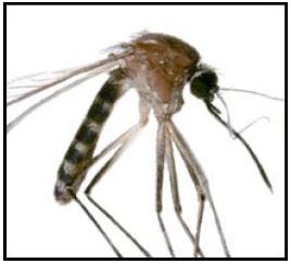 The Torres Strait is well known as a biological bridge, with many species moving between the islands and mainland Australia. Of global concern is the risk that emerging infectious diseases could have on human and wildlife health and that the Torres Strait could facilitate disease movement to the Australian mainland.
Tropical Ecosystems Hub researchers are working to improve methods of detecting and monitoring disease that will result in increased capacity to protect Torres Strait biodiversity and people from disease.
The team from Project 11.2: Improved Approaches for Detection of Disease and Prevention of Spread in Torres Strait are improving our understanding of the distribution of disease vectors across the Torres Strait and developing new surveillance methods for detecting disease vectors.
The challenge of managing disease outbreaks in frontier regions is early detection of new vectors and diseases, but the isolated nature of these remote regions is that standard surveillance approaches are not appropriate. Standard sampling of vectors requires vector-attractants are unavailable or difficult to transport, without great expense.
The project team trialed both a passive mosquito trap design that does not require batteries and a vector attractant that produces CO2 from yeast and sugar. The novel sampling method whilst capturing fewer mosquitoes than the standard traps and dry ice attractants, did capture the same types of mosquito species which importantly reveals what disease vectors are common in the landscape. Further, the new sampling method was found to be more robust and efficient in remote locations compared to standard BG traps capturing up to 14 times more mosquitoes in forest habitats.
Twenty species of mosquitos were identified from the 4,655 individuals captured across four islands in the Torres Strait: Saibai, Boigu, Kubin and Badu. In total, five times more mosquitoes were recorded in forest habitats compared to villages, with Saibai and Boigu Islands recording 4-5 times more mosquitoes than Kubin and Badu Islands during the sampling period.
With respect to the disease-vectoring potential of the sampled mosquitoes, the malaria-vector Anopheles spp. was recorded only on Saibia and Boigu islands, with proportional high numbers (45% of Boigu total) on Boigu during the sampling period. Dengue vector Aedes albopictus was recorded in all sampled villages and in the forest of Badu. The other dengue vector Aedes aegypti was only recorded on Boigu Island.
Information from the project will assist Biosecurity Queensland and the Australian Quarantine Inspection Service in devising environmental disease management interventions in Torres Strait. The project also serves to inform communities in Torres Strait of the diseases that can be transmitted by mosquitos.
Dr. Ken Anthony, Dr. Nicholas Wolff, Prof. Peter Mumby, Dr. Eve McDonald-Madden and Dr. Michelle Devlin
The Great Barrier Reef faces a suite of environmental pressures, ranging from global climate change to local-scale impacts from declining water quality. The reported loss of coral cover on the GBR, however, has been attributed primarily to acute stress events: bleaching, cyclones and crown-of-thorns starfish. The impacts of chronic and cumulative pressures, which potentially increase coral sensitivity to stress and suppress coral recovery between disturbance events, have largely been discounted. Indeed, stress on the GBR is likely to accumulate, especially in light of rapid regional economic growth and current global warming predictions.
This collaborative and multidisciplinary project takes a forward look at GBR vulnerability under scenarios of both acute and chronic pressures. Specifically, using a model of coral growth, mortality and recovery, coral dynamics are predicted over 20-40 year horizons across 1,300 reefs, driven by global warming, cyclones, water quality and outbreaks of CoTS. Water quality is modelled based on river flows and nutrient loads propagated into the GBR lagoon using eReefs hydrodynamic models calibrated against observed chlorophyll dynamics. Further, the coral vulnerability model is integrated with structured decision analyses, providing a means to inform GBR spatial planning and decision-making (Figure 1).

Figure 1. Conceptual outline of the linked coral vulnerability model and decision-support framework (NERP TE Project 9.1). Arrows represent processes that are resolved quantitatively in the model. Ocean acidification (OA) is not formally included in the current model.
Under a business-as-usual scenario, climate change is predicted to become a strong driver of region-wide coral vulnerability as we approach year 2050, driven partly by systemic loss of coral resilience from ocean warming. Varying land-use management alternatives across catchments produce different spatial coral vulnerability patterns, opening new opportunities for targeted management. Our tentative initial conclusions suggest that the modelled scenario that has the strongest predicted impact on coral vulnerability is for agricultural development of the Normanby catchment (lower Cape York). Here, high, simulated levels of nutrient export into Princess Charlotte Bay lead to high chlorophyll levels that initiate CoTS outbreaks propagating north into the Cape York region (Figure 2).

Figure 2. Modelled coral vulnerability (percent decline in coral cover) in the Cape York section of the GBR. Panel A shows predicted coral vulnerability over a 20-year horizon based on current water quality. Panel B shows coral vulnerability under a simulated 75% increase in dissolved inorganic nitrogen loading and 10% increase in suspended sediment exported by the Normanby River. Results are means of 100 simulations.
This project is the first to integrate drivers of global environmental change with chronic and acute pressures at the local scale within a linked predictive modelling and decision-support framework. The project team is now preparing to communicate the preliminary modelling results and the decision analyses to the GBR Marine Park Authority, Department of the Environment, Department of Environment and Heritage and other interested stakeholders. With this consultation and engagement process we hope to achieve the following three objectives: (1) collaboratively explore the impacts of different local and regional development scenarios (e.g. changes in land-use practices), (2) examine options and scope for management interventions (e.g. spatial planning, direct CoTS control) and (3) determine their cost-effectiveness in reducing coral vulnerability and sustaining the GBR in the long term.
For more information, contact Dr. Ken Anthony (k.anthony@aims.gov.au) or Prof. Peter Mumby (p.j.mumby@uq.edu.au).

Dr. Cathy Dichmont (CSIRO)
Shaping the future of the Great Barrier Reef is no easy task. The Reef catchment area covers almost 350,000 square kilometres. The region contributes $7 billion to the Australian economy annually, primarily through tourism, however farming, fishing and the research sectors are also important.
Future management decisions regarding the Reef need to strike the right balance between economic growth, environmental protection and community wellbeing.
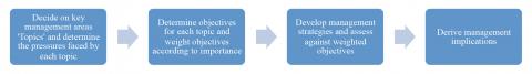
To ensure all voices are heard in the decision-making process, CSIRO and partners are creating a framework to empower local people to contribute to local management decisions through a case study in Mackay.
Community acceptance of decisions surrounding the Great Barrier Reef’s future is reliant on transparency and grassroots involvement. With this in mind, a ‘bottom-up’ framework has been developed by CSIRO to empower local community members to affect local decisions. Representatives from across the community are working collaboratively to determine key areas that will require future management decisions.
To do this, the representatives prioritise management objectives from the most important to least important using a novel way to solicit information. The prioritisation framework gives Reef managers and decision makers vital information on what is important to each stakeholder group, what they all agree on and how willing they are to negotiate on each objective. Management decisions are then elicited from the community representatives and assessed against the ranked objectives to determine the likely impacts of each decision.
The framework was developed and tested in Mackay with a large group of stakeholders including local residents, farmers, fishers, tourism operators, community and environmental groups, plus decision makers across government.
The decision makers that will use the findings from the project to inform future strategies for Mackay include Mackay Regional Council, Queensland Government (fisheries and parks), the Ports Corporation and the Federal Government’s Great Barrier Reef Marine Park Authority.
With a focus on the coasts’ fisheries and biodiversity, six key topics were agreed on and explored by the group: mangroves, seagrasses, inshore corals, fisheries, urban development and ports.
The stakeholder group identified the economic, environmental and social pressures associated with each of these topics, and based on those threats, determined the best management action to address these pressures.
For example, the three most important objectives identified by the stakeholder group are “Reduce direct impacts of infrastructure and development”, “Reduce influx of pollutants” and “Increase compliance with environmental and resource use regulations”. The key actions to address these objectives therefore focused on cumulative impacts and measures to increase compliance to existing legislation through changes to existing practices and education campaigns. Based on the pressures and weighted objectives, the impacts of these management options could be quantitatively tested, determining the possible consequences, advantages and limitations of each decision.
Within six months the management framework will be finalised and demonstrated in Mackay. Once trialled and evaluated, we plan for this framework to be rolled out and customised across any coastal community in Australia.
For more information, contact Dr. Cathy Dichmont (cathy.dichmont@csiro.au)
Climate change and other evolving issues present both challenges and opportunities to Torres Strait communities. In order to assist communities and governance structures to think about the future, an ‘Adaptation Integration Workshop’ was held on Thursday Island from 23 July - 25 July. The workshop was led by CSIRO with support from TSRA.
The Integration Workshop was a key event in the NERP project “Building Resilient Communities for Torres Strait Futures”. It synthesised and built on knowledge shared in five previous workshops that the team has held since 2012. Ultimately, the Integration Workshop provided a powerful opportunity for participants to consider how they would like Torres Strait Island communities to develop over the coming years, what challenges and opportunities are involved, and how to build community strength and resilience.
Twenty-five participants attended, representing a mix of community leaders, community members, and Queensland government stakeholders; some of whom had participated in earlier workshops. These included a government stakeholder workshop in Cairns, and community workshops on Masig, Erub and Mabuiag Islands. Each of these earlier workshops considered how climate change and other pressures might impact on key resources used and valued by the communities, and developed some scenarios of possible futures for the three communities and the Torres Strait region.
In the Integration Workshop, participants discussed the feasibility of strategies identified in the preceding workshops, explored adaptation strategies, and assessed how these aligned with existing programs in the Torres Strait. While the workshop focused on Masig as a “pilot study”, participants in the Erub and Mabuiag community workshops shared their experiences and insights. The learning between communities was considered to be a valuable outcome of the workshop.
Workshop results will be provided to the communities and will link to a broader regional Torres Strait Adaptation and Resilience project led by TSRA, who ran a separate but related workshop on Thursday Island earlier in the week. The two workshops were held back-to-back to facilitate attendance of community leaders and members and government representatives involved in both, and to maximise opportunities to share insights and learning across workshops.
In addition to feeding into TSRA’s community-based climate adaptation planning process for the region, the project approach and outputs are also being used by the Queensland Government Department of Aboriginal and Torres Strait Islander and Multicultural Affairs for its draft planning scheme proposal for Torres Strait communities. Next steps for the project include evaluating project achievements, training of TSRA staff in project modelling tools, and developing video products for community and government audiences.
For more information, contact Dr Erin Bohensky from CSIRO at erin.bohensky@csiro.au.
E.T. da Silva, M.J. Devlin, J. G. Alvarez-Romero, A. Wenger & L. I.W. McKinna, Integration of satellite imagery and in-situ data for the identification of surface water quality conditions in the Great Barrier Reef.
 The RRRC is a not-for-profit consortium of research providers, industry and community organisations that cooperate via a strong and effective engagement framework.

The Tropical Ecosystems Hub newsletter for April 2014 contains reports from seven quite different projects and all geographical Nodes. From the Torres Strait, a collaborative project between Hub researchers and the indigenous ranger program has shown that island mangrove habitats are generally intact and in good condition. While these surveys have doubled the number of species recorded by past scientific surveys, the rangers were able to supply local language names for the entire new flora indicating the value of the detailed knowledge held by Traditional Owners. From the Great Barrier Reef, Hub researchers are tapping into the perceptions and values of a wide range of residents and visitors to create unique baselines for future monitoring of the social and economic dimensions of system health and the resilience of coastal communities. From the Wet Tropics, the principal regional management authority is currently connecting research outcomes from multiple Hub projects with Queensland Government staff responsible for policy formulation and management of this World Heritage Area. The common element in these three examples is the connectivity between Hub researchers and research users to generate and transfer new knowledge of practical value for the protection and conservation of these major environmental assets. As the Tropical Ecosystems Hub enters its completion phase, it is satisfying from my perspective to see that all 39 projects are making similar contributions in this style. I hope that you find this small selection informative of the power of the collaborative research model.
Dr. Peter Doherty, AIMS
For more information, contact Dr. Peter Doherty at: p.doherty@aims.gov.au
Pages
Latest News
- Laws protecting the Great Barrier Reef to be introduced next week, Queensland Premier says - Thu 28th May 2015
- Let’s get serious about protecting wildlife in a warming world - Thu 28th May 2015
- We’ve only monitored a fraction of the Barrier Reef’s species - Thu 28th May 2015
- Great Barrier Reef: warmer waters helping coral-eating starfish thrive - Fri 13th Feb 2015
- You are what you eat—if you're a coral reef fish - Wed 17th Dec 2014

Current search
Search found 254 items
- [all items]
