e-Atlas update
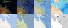
The e-Atlas has expanded its range of base layers to incorporate some of the best maps and imagery available on the web. Layers from Google, Bing, ArcGIS Online, Open Street Map and Stamendesign are now all directly available in the e-Atlas mapping portal.
You can now compare imagery from multiple sources in one place and use these as base layers for research data.
The range of terrestrial data has been expanded by the integration of over 350 layers from the Atlas of Living Australia. In the future most of the content available from the Australian Ocean Data Network will also be available through the e-Atlas. The ‘lite’ version of the Digital Cadastral Database (DNRM) has been integrated into the e-Atlas as a reference layer for the Wet Tropics Management Authority Vegetation Portal, currently in development.
With this you can now use the e-Atlas to find out the Lot number, Plan number and area of any property in Queensland. In the coming months the first round of emerging research data from the NERP-TE projects will be incorporated into the e-Atlas.
Image: Selection of the 24 new base layers available through the e-Atlas.
For more information contact Eric Lawrey
Latest News
- Laws protecting the Great Barrier Reef to be introduced next week, Queensland Premier says - Thu 28th May 2015
- Let’s get serious about protecting wildlife in a warming world - Thu 28th May 2015
- We’ve only monitored a fraction of the Barrier Reef’s species - Thu 28th May 2015
- Great Barrier Reef: warmer waters helping coral-eating starfish thrive - Fri 13th Feb 2015
- You are what you eat—if you're a coral reef fish - Wed 17th Dec 2014

