Conservation Planning for a Changing Coastal Zone
Conservation Planning for a Changing Coastal Zone
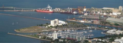
Intensive development in the coastal zone adjacent the Great Barrier Reef has led to degradation of coastal ecosystems that threatens the health of the GBR.
NERP Tropical Ecosystems Hub researchers from James Cook University are developing new methods of conservation planning based on mapping potential future scenarios to help guide planning for use of the coastal zone.
The key economic activities on land in the GBR coastal zone are related to shipping, intensive agriculture, urban development, and tourism. All these activities are set to expand and intensify in the future.
Systematic conservation planning determines the best spatial use of limited conservation resources to minimise the loss of valued aspects of the natural world in the future. It is faced with a significant challenge with coastal development because it is difficult to predict so threats to ecosystems and species are highly uncertain.
This challenge is increased by the necessity to account for cumulative impacts of all coastal development and activities in the coastal zone. A novel approach is required that integrates the uncertainty of the future and cumulative impacts to identify conservation areas that will be relevant and effective in the future.
 Project 9.4 develops a new methodology called scenario-based systematic conservation planning. It brings together the research fields of scenario planning, spatial modelling, governance analysis, ecological impact assessments and systematic conservation planning. First, this method uses spatially explicit scenario planning to identify plausible futures to 2035 for the GBR coastal zone.
Land use change modelling to map eight scenarios is done using spatial data, on land use, tourism, vegetation and sea level rise. Spatial marine use related to the land use development (e.g. shipping) is added to the scenarios.
The scenario maps are used to conduct ecological impact assessments in each scenario on identified environmental assets of the coastal zone such as water quality, seagrass and dugongs. The scenarios will also produce maps of disturbance probability and anticipated transition to urban land use across all scenarios.
Comparison of effects of governance systems on impacts on environmental assets is used to conduct governance analysis. Results of these analyses are finally brought together in a systematic conservation planning exercise. This will assist with prioritising conservation efforts and inform decisions on the most effective use of limited conservation resources and protection measures for the GBR coastal zone.
Dr. Amélie Augé, JCU
For more information, contact Amélie Augé at: amelie.auge@jcu.edu.au
Project: 9.4: Conservation planning for a changing coastal zone

Latest News
- Laws protecting the Great Barrier Reef to be introduced next week, Queensland Premier says - Thu 28th May 2015
- Let’s get serious about protecting wildlife in a warming world - Thu 28th May 2015
- We’ve only monitored a fraction of the Barrier Reef’s species - Thu 28th May 2015
- Great Barrier Reef: warmer waters helping coral-eating starfish thrive - Fri 13th Feb 2015
- You are what you eat—if you're a coral reef fish - Wed 17th Dec 2014

Search by Publication Type
- Media Report (204)
- Journal Article (163)
- Conference / Workshop Presentation (101)
- eNewsletter Article (52)
- Technical / Research Report (51)
- Project Factsheet (38)
- Research Synthesis Product (34)
- Final Report / Factsheet (34)
- Poster (23)
- Project Result Factsheet (23)
- Hub administration (17)
- Book Chapter (10)
- NERP TE Hub eNewsletters (9)
- Magazine Articles (8)
- Communiqué (6)
- Project Factsheet for the Torres Strait Community (6)
- Workshop Summary (5)
- Video (5)
- Brochure (3)
- Audio (3)
- News Article (2)
- Unknown (2)
- Guide (1)
- August 2013 e-Newsletter (1)
- June 2013 e-Newsletter (1)
- November 2013 eNewsletter (1)
- Project Factsheet for Traditional Owners (1)
- February 2014 eNewsletter (1)
- April 2014 e-Newsletter (1)
- June 2014 e-Newsletter (1)
- August 2014 e-Newsletter (1)
Search by Project
- Project 11.1 'Building resilient communities for Torres Strait futures' (45)
- Project 10.2 'Socio-economic systems and reef resilience' (41)
- Project 10.1 'Social and Economic Long Term Monitoring Program (SELTMP)' (33)
- Project 3.1 'Rainforest Biodiversity' (24)
- Project 12.1 'Indigenous co-management and biodiversity protection' (23)
- Project 7.2 'Invasive species risks and responses in the Wet Tropics' (21)
- Project 3.3 'Targeted surveys for missing and critically endangered rainforest frogs in ecotonal areas, and assessment of whether populations are recovering from disease' (20)
- Project 5.3 'Vulnerability of seagrass habitats in the Great Barrier Reef to flood plume impacts: light, nutrients, salinity' (20)
- Project 2.1 'Marine turtles and dugongs of the Torres Strait' (19)
- Project 12.2 'Harnessing natural regeneration for cost-effective rainforest restoration' (19)
- Project 2.3 'Monitoring the health of Torres Strait coral reefs' (17)
- Project 3.4 'Monitoring of key vertebrate species' (17)
- Project 5.2 'Experimental and field investigations of combined water quality and climate effects on corals and other reef organisms' (17)
- Project 1.3 'Characterising the cumulative impacts of global, regional and local stressors on the present and past biodiversity of the Great Barrier Reef' (17)
- Project 4.2 'The chronic effects of pesticides and their persistence in tropical waters' (15)
- Project 3.2 'What is at risk? Identifying rainforest refugia and hotspots of plant genetic diversity in the Wet Tropics and Cape York Peninsula' (14)
- Project 6.1 'Maximising the benefits of mobile predators to Great Barrier Reef ecosystems: the importance of movement, habitat and environment' (14)
- Project 7.3 'Climate change and the impacts of extreme climatic events on Australia's Wet Tropics biodiversity' (14)
- Project 9.4 'Conservation planning for a changing coastal zone' (14)
- Project 2.2. 'Mangrove and freshwater habitat status of Torres Strait islands' (13)
- Project 1.1 'Monitoring status and trends of coral reefs of the Great Barrier Reef' (13)
- Project 4.4 'Hazard assessment for water quality threats to Torres Strait marine waters, ecosystems and public health' (13)
- Project 6.2 'Drivers of juvenile shark biodiversity and abundance in inshore ecosystems of the Great Barrier Reef' (13)
- Project 8.3 'Significance of no-take marine protected areas to regional recruitment and population persistence on the Great Barrier Reef' (13)
- Project 12.4 'Governance, planning and the effective application of emerging ecosystem service markets to secure climate change adaptation and landscape resilience in far north Queensland' (13)
- Project 7.1 'Fire and rainforests' (12)
- Project 6.3 'Critical seabird foraging locations and trophic relationships for the Great Barrier Reef' (11)
- Project 8.1 'Monitoring the ecological effects of the Great Barrier Reef zoning plan on mid and outer shelf reefs' (11)
- Project 8.2 'Do no-take marine reserves contribute to biodiversity and fishery sustainability? Assessing the effects of management zoning on inshore reefs of the Great Barrier Reef Marine Park' (11)
- Project 11.2 'Improved approaches for detection of disease and prevention of spread in Torres Strait' (11)
- Project 5.1 'Understanding diversity of the Great Barrier Reef: Spatial and temporal dynamics and environmental drivers' (10)
- Project 12.3 'Relative social and economic values of residents and tourists in the Wet Tropics World Heritage Area' (10)
- Project 1.2 'Marine wildlife management in the Great Barrier Reef World Heritage Area' (10)
- Project 13.1 'e-Atlas for the Great Barrier Reef and Torres Strait' (10)
- Project 9.2 'Design and implementation of Management Strategy Evaluation for the Great Barrier Reef inshore (MSE-GBR)' (9)
- Project 4.1 'Tracking coastal turbidity over time and demonstrating the effects of river discharge events on regional turbidity in the Great Barrier Reef' (9)
- Project 9.1 'Dynamic vulnerability maps and decision support tools for the Great Barrier Reef' (7)
- Project 9.3 'Prioritising management actions for Great Barrier Reef islands' (7)
- Project 4.3 'Ecological risk assessment of pesticides, nutrients and sediments on water quality and ecosystem health - Phase 1' (5)
