Developing Guidelines for the Protection of GBR Seagrass Habitats
Developing Guidelines for the Protection of GBR Seagrass Habitats
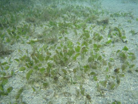 Seagrass meadows are vital habitat in tropical coastal ecosystems. However, ongoing monitoring indicates that seagrass meadows are in decline in the Great Barrier Reef where they are exposed to a range of stressors that reduce their capacity to recover after major disturbances.
Tropical Ecosystems Hub researchers used complementary laboratory and field experiments to investigate the cumulative impacts of exposure of seagrass meadows to diminished light, increased nutrients and decreased salinity, conditions that occur when water quality is reduced such as flooding and dredging.
The purpose of the research is the development of guidelines for the Great Barrier Reef Marine Park Authority (GBRMPA) for the protection of seagrass meadows, including guiding improvement to the existing Marine Monitoring Program.
The team from Project 5.3 Vulnerability of seagrass habitats in the GBR to flood plume impacts: light, nutrients and salinity tested seagrass vulnerability to water quality stressors that are typical during wet season runoff. The experiments tested environmental thresholds as well as lethal and sub-lethal indicators of stress. The tests were developed in conjunction with the GBRMPA.
This project team also mapped water quality using remote sensing, which can be used to update existing seagrass risk models. The work has provided robust and scientifically defensible environmental thresholds and has significantly enhanced the ability to detect and interpret responses to changes in water quality through high-resolution indicators testing.
The guidelines that will be developed from this project include four seagrass species and seasonally different temperatures. These will generate thresholds for species, temperature and time of light reduction. This will mean that for a specific time of exposure (e.g. duration of dredging program), the GBRMPA can state the light level required to meet that guideline. As an example, for 50% protection of seagrass density, being exposed to low light conditions for 3 months, 22.6% of surface irradiance or 7.4 mol photons m-2 d-1 is required for Z. muelleri at summer temperatures.
Large-scale water quality mapping can help define the type of seagrass communities and identify the main water types, which shape and drive seagrass response. Consequently, long term water quality data, both in-situ and through remote sensing, can provide measures of risk relative to the seagrass community health, including measures of seagrass biomass, cover and species.
This study has significantly advanced the certainty with which seagrass protection guidelines can be applied.

Latest News
- Laws protecting the Great Barrier Reef to be introduced next week, Queensland Premier says - Thu 28th May 2015
- Let’s get serious about protecting wildlife in a warming world - Thu 28th May 2015
- We’ve only monitored a fraction of the Barrier Reef’s species - Thu 28th May 2015
- Great Barrier Reef: warmer waters helping coral-eating starfish thrive - Fri 13th Feb 2015
- You are what you eat—if you're a coral reef fish - Wed 17th Dec 2014

Search by Publication Type
- Media Report (204)
- Journal Article (163)
- Conference / Workshop Presentation (101)
- eNewsletter Article (52)
- Technical / Research Report (51)
- Project Factsheet (38)
- Research Synthesis Product (34)
- Final Report / Factsheet (34)
- Poster (23)
- Project Result Factsheet (23)
- Hub administration (17)
- Book Chapter (10)
- NERP TE Hub eNewsletters (9)
- Magazine Articles (8)
- Communiqué (6)
- Project Factsheet for the Torres Strait Community (6)
- Workshop Summary (5)
- Video (5)
- Brochure (3)
- Audio (3)
- News Article (2)
- Unknown (2)
- Guide (1)
- August 2013 e-Newsletter (1)
- June 2013 e-Newsletter (1)
- November 2013 eNewsletter (1)
- Project Factsheet for Traditional Owners (1)
- February 2014 eNewsletter (1)
- April 2014 e-Newsletter (1)
- June 2014 e-Newsletter (1)
- August 2014 e-Newsletter (1)
Search by Project
- Project 11.1 'Building resilient communities for Torres Strait futures' (45)
- Project 10.2 'Socio-economic systems and reef resilience' (41)
- Project 10.1 'Social and Economic Long Term Monitoring Program (SELTMP)' (33)
- Project 3.1 'Rainforest Biodiversity' (24)
- Project 12.1 'Indigenous co-management and biodiversity protection' (23)
- Project 7.2 'Invasive species risks and responses in the Wet Tropics' (21)
- Project 3.3 'Targeted surveys for missing and critically endangered rainforest frogs in ecotonal areas, and assessment of whether populations are recovering from disease' (20)
- Project 5.3 'Vulnerability of seagrass habitats in the Great Barrier Reef to flood plume impacts: light, nutrients, salinity' (20)
- Project 2.1 'Marine turtles and dugongs of the Torres Strait' (19)
- Project 12.2 'Harnessing natural regeneration for cost-effective rainforest restoration' (19)
- Project 2.3 'Monitoring the health of Torres Strait coral reefs' (17)
- Project 3.4 'Monitoring of key vertebrate species' (17)
- Project 5.2 'Experimental and field investigations of combined water quality and climate effects on corals and other reef organisms' (17)
- Project 1.3 'Characterising the cumulative impacts of global, regional and local stressors on the present and past biodiversity of the Great Barrier Reef' (17)
- Project 4.2 'The chronic effects of pesticides and their persistence in tropical waters' (15)
- Project 3.2 'What is at risk? Identifying rainforest refugia and hotspots of plant genetic diversity in the Wet Tropics and Cape York Peninsula' (14)
- Project 6.1 'Maximising the benefits of mobile predators to Great Barrier Reef ecosystems: the importance of movement, habitat and environment' (14)
- Project 7.3 'Climate change and the impacts of extreme climatic events on Australia's Wet Tropics biodiversity' (14)
- Project 9.4 'Conservation planning for a changing coastal zone' (14)
- Project 2.2. 'Mangrove and freshwater habitat status of Torres Strait islands' (13)
- Project 1.1 'Monitoring status and trends of coral reefs of the Great Barrier Reef' (13)
- Project 4.4 'Hazard assessment for water quality threats to Torres Strait marine waters, ecosystems and public health' (13)
- Project 6.2 'Drivers of juvenile shark biodiversity and abundance in inshore ecosystems of the Great Barrier Reef' (13)
- Project 8.3 'Significance of no-take marine protected areas to regional recruitment and population persistence on the Great Barrier Reef' (13)
- Project 12.4 'Governance, planning and the effective application of emerging ecosystem service markets to secure climate change adaptation and landscape resilience in far north Queensland' (13)
- Project 7.1 'Fire and rainforests' (12)
- Project 6.3 'Critical seabird foraging locations and trophic relationships for the Great Barrier Reef' (11)
- Project 8.1 'Monitoring the ecological effects of the Great Barrier Reef zoning plan on mid and outer shelf reefs' (11)
- Project 8.2 'Do no-take marine reserves contribute to biodiversity and fishery sustainability? Assessing the effects of management zoning on inshore reefs of the Great Barrier Reef Marine Park' (11)
- Project 11.2 'Improved approaches for detection of disease and prevention of spread in Torres Strait' (11)
- Project 5.1 'Understanding diversity of the Great Barrier Reef: Spatial and temporal dynamics and environmental drivers' (10)
- Project 12.3 'Relative social and economic values of residents and tourists in the Wet Tropics World Heritage Area' (10)
- Project 1.2 'Marine wildlife management in the Great Barrier Reef World Heritage Area' (10)
- Project 13.1 'e-Atlas for the Great Barrier Reef and Torres Strait' (10)
- Project 9.2 'Design and implementation of Management Strategy Evaluation for the Great Barrier Reef inshore (MSE-GBR)' (9)
- Project 4.1 'Tracking coastal turbidity over time and demonstrating the effects of river discharge events on regional turbidity in the Great Barrier Reef' (9)
- Project 9.1 'Dynamic vulnerability maps and decision support tools for the Great Barrier Reef' (7)
- Project 9.3 'Prioritising management actions for Great Barrier Reef islands' (7)
- Project 4.3 'Ecological risk assessment of pesticides, nutrients and sediments on water quality and ecosystem health - Phase 1' (5)
